Sunday, 29 November 2009

China - Summer Palace


Long Corridor


Seventeen-Arch Bridge


Marble Boat


Garden of Harmonious Pleasure


Jade Belt Bridge


Back Lake
Stamp Issue:10 May 2008

The Summer Palace or Yihe yuan (literally "Gardens of Nurtured Harmony") is a palace in Beijing, China. The Summer Palace is mainly dominated by Longevity Hill (60 meters high) and the Kunming Lake. It covers an expanse of 2.9 square kilometers, three quarters of which is water. The central Kunming Lake covering 2.2 square kilometers was entirely man made and the excavated soil was used to build Longevity Hill. In the Summer Palace, one finds a variety of palaces, gardens, and other classical-style architectural structures.
The Summer Palace started out life as the Garden of Clear Ripples in 1750 (Reign Year 15 of Emperor Qianlong). Artisans reproduced the garden architecture styles of various palaces in China. Kunming Lake was created by extending an existing body of water to imitate the West Lake in Hangzhou. The palace complex suffered two major attacks--during the Anglo-French allied invasion of 1860 (with the Old Summer Palace also ransacked at the same time), and during the Boxer Rebellion, in an attack by the eight allied powers in 1900. The garden survived and was rebuilt in 1886 and 1902. In 1888, it was given the current name, Yihe Yuan. It served as a summer resort for Empress Dowager Cixi, who diverted 30 million taels of silver, said to be originally designated for the Chinese navy (Beiyang Fleet), into the reconstruction and enlargement of the Summer Palace.
In December 1998, UNESCO included the Summer Palace on its World Heritage List. It declared the Summer Palace "a masterpiece of Chinese landscape garden design. The natural landscape of hills and open water is combined with artificial features such as pavilions, halls, palaces, temples and bridges to form a harmonious ensemble of outstanding aesthetic value." It is a popular tourist destination but also serves as a recreational park.

Tuesday, 24 November 2009

France - Bourges Cathedral


Stamp Issue:5 Jun 1965

Cathédrale Saint-Étienne de Bourges) is a cathedral, dedicated to Saint Stephen, located in Bourges, France. It is the seat of the Archbishop of Bourges.
Construction on Bourges Cathedral began on in 1195, the same time as Chartres Cathedral. The choir was completed by 1214 and the nave was completed in 1225-1250. The west façade was finished in 1270. The architect was Paul-Louis Boeswillwald and the master builder was Philip Berruyer.
The cathedral was added to the list of the World Heritage Sites by UNESCO in 1992.

Germany - Reichenau


Stamp Issue: 2 Jan 2008

Reichenau Island lies in Lake Constance in southern Germany. It lies between the Gnadensee and the Untersee, almost due west of the city of Konstanz. The island is connected to the mainland by a causeway that was completed in 1838. Nevertheless, the island is separated from it by a 10-meter-wide Bruckgraben, which is spanned by a low road bridge that allows passage of ordinary boats but not of sailboats through its 95-meter course. The highest elevation on the island, the Hochwart, reaches 438.7 meters, or 43 meters above the lake surface.
It was declared a World Heritage Site in 2000 because of its monastery, the Abbey of Reichenau. The abbey's Münster is dedicated to the Virgin and Saint Mark. Two further churches were built on the island consecrated to St Georg, and to Sts Peter and Paul. The famous artworks of Reichenau include the Ottonian murals of miracles of Christ in St Georg, unique survivals from the 10th century. The abbey's bailiff was housed in a two-storey stone building that was raised by two more storeys of timber framing in the 14th century, one of the oldest timber-frame buildings in south Germany.
Among the Abbey's far-flung landholdings was Reichenau, a village in the municipality of Tamins in the canton of Graubünden, named for the Abbey.
Today the island is also famous for its vegetable farms and wineries. The Wollmatinger Ried next to the island is a big nature preserve, a wetland area of reeds which is used by many birds for the stopover during their annual migration.

UK - Giant's Causeway


Stamp Issue: 24 Jun 1981 (Honeycomb)


Stamp Issue: 8 Jun 1999?


Stamp Issue:16 Mar 2004 (Antrim Parlour)


Stamp Issue:11 Mar 2008 (Wishing Chair in the Honeycomb)

The Giant's Causeway (or Irish: Clochán na bhFómharach) is an area of about 40,000 interlocking basalt columns, the result of an ancient volcanic eruption. It is located on the northeast coast of Northern Ireland, about two miles (3 km) north of the town of Bushmills. It was declared a World Heritage Site by UNESCO in 1986, and a National Nature Reserve in 1987 by the Department of the Environment for Northern Ireland. In a 2005 poll of Radio Times readers, the Giant's Causeway was named as the fourth greatest natural wonder in the United Kingdom. The tops of the columns form stepping stones that lead from the cliff foot and disappear under the sea. Most of the columns are hexagonal, although there are also some with four, five, seven and eight sides. The tallest are about 12 metres (36 ft) high, and the solidified lava in the cliffs is 28 metres thick in places.
During the Paleogene period, Antrim was subject to intense volcanic activity, when highly fluid molten basalt intruded through chalk beds to form an extensive lava plateau. As the lava cooled rapidly, contraction occurred. While contraction in the vertical direction reduced the flow thickness (without fracturing), horizontal contraction could only be accommodated by cracking throughout the flow. The extensive fracture network produced the distinctive columns seen today. The basalts were originally part of a great volcanic plateau called the Thulean Plateau which formed during the Paleogene period.

UK - St Kilda


Stamp Issue: 24 Jun 1981

St Kilda (Scottish Gaelic: Hiort) is an isolated archipelago 64 kilometres (40 mi) west-northwest of North Uist in the North Atlantic Ocean. It contains the westernmost islands of the Outer Hebrides of Scotland. The largest island is Hirta, whose sea cliffs are the highest in the United Kingdom. The Gaelic-speaking population probably never exceeded 180 and was never more than 100 after 1851. Although St Kilda was permanently inhabited for at least two millennia, and despite the inhabitants' unique way of life, the entire population was evacuated in 1930. The only residents are now military personnel. The islands are administratively a part of the Comhairle nan Eilean Siar local authority area.
The origin of the name St Kilda is a matter of conjecture. The islands' human heritage includes numerous unique architectural features from the historic and prehistoric periods, although the earliest written records of island life date from the Late Middle Ages. The medieval village on Hirta was rebuilt in the 19th century, but the influences of religion, tourism and the First World War contributed to the island's evacuation in 1930. The story of St Kilda has attracted artistic interpretations, including a recent opera.
The entire archipelago is owned by the National Trust for Scotland. It became one of Scotland's four World Heritage Sites in 1986 and is one of the few in the world to hold joint status for its natural, marine and cultural qualities. The islands are a breeding ground for many important seabird species including Northern Gannets, Atlantic Puffins, and Northern Fulmars. The St Kilda Wren and St Kilda Field Mouse are endemic sub-species. Parties of volunteers work on the islands in the summer months to restore the many ruined buildings the native St Kildans left behind. They share the island with a small military base created in 1957.

UK - Westminster Abbey


Stamp Issue: 9 Apr 1980
Above two stamps are slightly different. (The face value 50 and the top of the Queen's crown)

The Collegiate Church of St Peter at Westminster, which is almost always referred to popularly and informally as Westminster Abbey, is a large, mainly Gothic church, in Westminster, London, just to the west of the Palace of Westminster. It is the traditional place of coronation and burial site for English, later British and later still (and currently) monarchs of the Commonwealth Realms. It briefly held the status of a cathedral from 1546–1556, and is a Royal Peculiar.

UK - Tower Bridge


Stamp Issue:10 Sep 2002

Tower Bridge is a combined bascule and suspension bridge in London, England over the River Thames. It is close to the Tower of London, which gives it its name. It has become an iconic symbol of London. Tower Bridge is one of several London bridges owned and maintained by the City Bridge Trust, a charitable trust overseen by the City of London Corporation.
The bridge consists of two towers which are tied together at the upper level by means of two horizontal walkways which are designed to withstand the horizontal forces exerted by the suspended sections of the bridge to the left and the right. The vertical component of the forces in the suspended sections and the vertical reactions of the two walkways are carried by the two robust towers. The bascule pivots and operating machinery are housed in the base of each tower.
Tower Bridge is sometimes mistakenly referred to as London Bridge, which is actually the next bridge upstream.A popular urban legend is that, in 1968 Robert McCulloch, the purchaser of the old London Bridge which was later shipped to Lake Havasu City, Arizona, believed mistakenly that he was buying Tower Bridge, but this was denied by McCulloch himself and has been debunked by Ivan Luckin, the seller of the bridge.Its present colour dates from 1977 when it was painted red, white and blue for the Queen's Silver Jubilee. Previous to this, it was painted a chocolate brown colour.

UK - Caernarfon Castle (Caernarvon Castle)


Stamp Issue: 1 Mar 1978


Stamp Issue: 18 Oct 1988


Stamp Issue: 24 Mar 1992


Stamp Issue: 22 Mar 2005

Caernarfon Castle (Welsh: Castell Caernarfon) was constructed at Caernarfon in Gwynedd, north-west Wales, by King Edward I of England, following his conquest of the country in 1283.
Edward I built castles and walled towns in North Wales to control the area following his conquest of the independent principality of Wales, in 1283.
Llywelyn ap Gruffudd, prince of Wales, having rejected a bribe of one thousand pounds a year and an estate in England, if he would surrender his nation unreservedly to the king of England, had been lured into a trap on 11 December 1282, and put to death. His brother Dafydd ap Gruffudd had continued the struggle for continuing independence, but had been captured at Bera Mountain in the uplands above Garth Celyn, in June 1283.
Edward surrounded and overshadowed Garth Celyn, the royal home and the headquarters of resistance to English domination, with Caernarfon and Conwy castles, and later Beaumaris Castle. The other fortress in the iron ring encirling Snowdonia was Harlech Castle.
The site selected for Caernarfon was strategically important, located on the banks of the River Seiont where it flows into the Menai Strait. It had been the site of a Roman fort, and a later motte and bailey castle built c. 1090 by Hugh d'Avranches. The castle was, at the time, surrounded on two sides by water, and the other by the Caernarfon city walls, but in the 19th century, the area on the River Seiont was filled in to enlarge the port of Caernarfon, and is today part of the castle's car park.
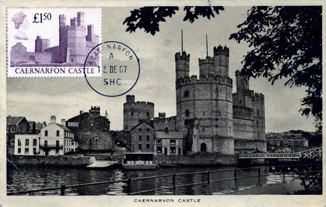
Begun in 1283 after Snowdonia - the heartland of Gwynedd - had been overrun by the massive army, it reached something like its current state in 1323. It was never completed, and even today there are joints visible in several places on the internal walls ready to accept further walls which were never built. Contemporary records note that the castle's construction cost some £22,000 – an enormous sum at the time, equivalent to more than a year's income for the royal treasury. The castle's linear design is sophisticated by comparison with earlier British castles, and the walls are said to have been modelled on those of Constantinople, Edward being a keen Crusader. The castle dominates the Menai Strait.